GeoCam and UCLA: Modernizing Campus Accessibility Mapping
In early 2025, UCLA partnered with GeoCam to capture and modernize its pedestrian infrastructure data. The goal was ambitious but clear: to produce a high-accuracy, imagery-backed digital map of every sidewalk, pathway, ramp, and ADA-related feature on UCLA’s 419-acre campus.
The Challenge
With decades of campus evolution and ongoing construction, UCLA needed verified, measurable data to support accessibility audits, facilities management, and event planning, including the ability to plan for and support major events like the LA28 Summer Olympics. The existing sidewalk map provided limited value: it contained centerline data only, with no information on surface types, vertical features (such as stairs and ramps), actual widths, or slopes.
As a result, UCLA’s Mobility Planning & Traffic Systems team encountered difficulties as it worked to coordinate construction, assess accessibility, and optimize routes for visitors, especially those requiring accessible paths. A modern, comprehensive, and easily updatable dataset was required: something that could capture complex pedestrian environments while remaining verifiable and visually auditable.
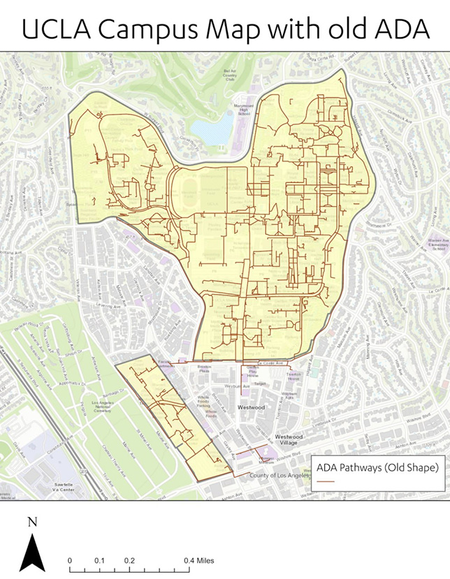 Old Map of UCLA
Image courtesy of GeoCam
The Results
The UCLA/GeoCam project produced over 600,000 images, more than 1,500 point features (ramps, stairs, and benches), 73 miles of sidewalk lines, 30,000 sidewalk vertices, and 2.6 million square feet of sidewalk polygons across the entire campus. Specific deliverables included:
- Esri ArcGIS feature services with polygons for sidewalks, ramps, and stairs
- Classified orthomosaics (captured below the tree canopy) for visual reference of sidewalks, vegetation, and buildings
- 3D meshes of complex areas such as plazas and staircases
- Access for immersive, browser-based 360° imagery inspection and further analysis
- Comprehensive QA documentation tracking edits and production rules
The outcome has been transformative. UCLA has effectively replaced a legacy line map with polygonal, ADA-ready features, achieving campus-wide consistency at sub-10 cm accuracy. Every ramp, staircase, and plaza has been mapped with clear attribution, enabling seamless remote collaboration and QA between UCLA and GeoCam teams. The dataset also establishes a digital twin foundation ready to support future university transportation and security planning, including preparation for LA28.
The Approach
Campus mapping is a complex, three-dimensional challenge. Most of the current tools are slow, difficult to use, or difficult to scale. Campuses like UCLA present additional obstacles, with complex topography, high-rise buildings, and dense vegetation.
The UCLA team knew that better data could improve campus operations. They had a preexisting GIS map of their sidewalks, but it was outdated, single-line, and built largely from aerial imagery. After seeing a demo of a new reality capture solution from GeoCam, it was clear that the technology could potentially provide a faster path to accurate mapping, with the resulting imagery would serve as a long-term resource for continuous improvement.
The project unfolded in three main phases: capture, processing, and data production and QA.
- Capture: Over two weeks in March and April 2025, GeoCam’s team imaged approximately 42 miles of sidewalks, plazas, and pathways. Equipped with a GeoCam 360° high-accuracy camera, they used a combination of walking, e-bikes, e-scooters, and vehicles to log high-resolution imagery, GNSS positions, and camera metadata of the entire campus.
- Processing and Alignment: Captured data was uploaded automatically to GeoCam’s cloud platform. GNSS post-processing refined trajectories, while visual positioning techniques filled gaps in shaded or obstructed areas. The resulting dataset achieved 10-cm 2D positional accuracy, covering every pedestrian surface with spatial continuity.
- Data Production and QA: Using a combination machine learning and human workflows GeoCam extracted sidewalk edges, ramps, stairs, and benches following strict production rules established by UCLA. QA dashboards tracked coverage, accuracy, and classification, while every feature was visually validated against the imagery, ensuring auditability and reliability.
The Impact
Beyond accessibility mapping, this project demonstrates how GeoCam can scale within complex environments. For LA28, it provides a model for high-accuracy, venue-scale pedestrian mapping. Specific to ADA compliance, it delivers measurable, visually verifiable documentation suitable for audits. Finally for security and operations, it supplies essential line-of-sight and access data to support crowd management and emergency planning.
Most importantly, the workflow is replicable. Any campus, venue, or city district can now benefit from rapid, affordable, and consistent high-accuracy mapping. The UCLA Sidewalks and ADA Mapping Project illustrates how imagery-driven GIS can modernize infrastructure planning, accessibility, and operational readiness.
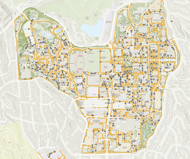 New Map of UCLA
Image courtesy of GeoCam
How It Was Accomplished
Working around student and campus schedules, the UCLA/GeoCam team deployed two cameras and captured the entire campus in a matter of days. Each 360° camera collected high-accuracy GNSS data and imagery at five shots per second (three images per shot), producing more than 600,000 images at 12 MP each.
The campus presented numerous staircases and ramps requiring dedicated imaging. GeoCam’s multi-modal system accommodated this seamlessly: a rider could park a bike, walk up or down a staircase to capture it, and resume riding. At the end of each day, all the imagery was automatically offloaded to external hard drives for archiving, while the camera simultaneously uploaded directly to the GeoCam Cloud, making it easy to remotely review and QA each day’s captures.
Given the variety of GNSS environments across the UCLA campus, GPS accuracy across hundreds of interlaced capture sessions. The GeoCam Cloud addressed this through a set of core processing services that fused all of the imagery into a single, unified scene. At the center of these services are GNSS post-processing and a Visual Positioning System. Each capture was processed individually, then a set of geographic cells fuses the captures together, to create an extremely accurate scene in which more than 600,000 images maintain the 10-cm accurate position and orientation requirements.
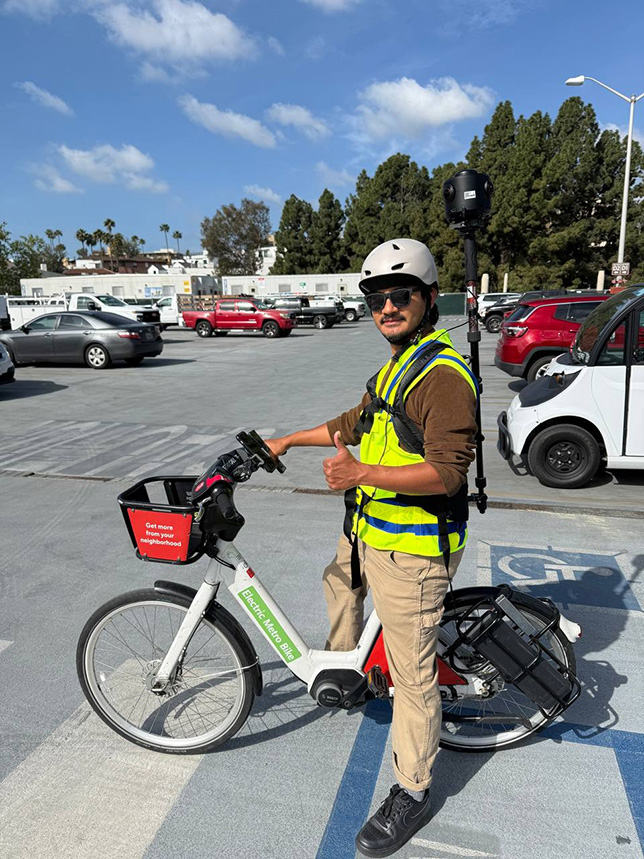 Image courtesy of GeoCam
The GeoCam system also deploys machine learning models to segment and detect objects, blurring people, vehicles, and other moving elements, and assisting in the subsequent sidewalk mapping stage.
The first output delivered to the UCLA team was via the GeoCam Viewer: a simple, scalable tool for reviewing captures and flagging areas requiring additional imagery, which allows the team to create and share short-linked “views” that encode field of view and map scale into the URL. Each of the 600,000 shots was georeferenced and oriented on top of a private Esri ArcGIS web map that the UCLA team can, now and in the future, modify with additional layers.
During QA process, a few small areas were identified as needing supplemental imagery. The UCLA/GeoCam team quickly deployed on foot to fill those gaps. One of the most powerful aspects of the technology is the ability to fuse these additional captures back into the original dataset, creating precise alignment and improving overall scene accuracy, especially in areas with poor GNSS signal. Once complete, the GeoCam Viewer was updated, and the UCLA part of the team began their own work using the imagery while GeoCam initiated AI-assisted data extraction for the sidewalk layer.
The data production process involved generating a rapid segmented mesh and deploying editing tools to map sidewalk edges, ramps, stairs, and other features with precision. The UCLA team members also processed 2D orthophoto renders (as GeoTIFF files) to provide additional environmental detail, with the important advantage that these renders were captured below the tree canopy, where traditional aerial imagery falls short. Using a combination of 360° imagery, machine learning outputs, and ortho renders, the team used tools within the GeoCam SaaS platform alongside Esri ArcGIS to manage a multi-contributor data production workflow, with contributions from both human analysts and automated systems.